Referring article: https://doi.org/10.1186/s12942-020-00202-8

On this page:

WHO COVID-19 dashboards

11 March 2020: COVID-19 confirmed as pandemic by WHO.

The WHO COVID-19 main dashboard is available at https://covid19.who.int/. There is also a WHO European Region COVID-19 dashboard at https://who.maps.arcgis.com/apps/opsdashboard/index.html#/ead3c6475654481ca51c248d52ab9c61.

[^Back to top of the page]

The University of Virginia Biocomplexity Institute dashboard with 'Time Slider' function

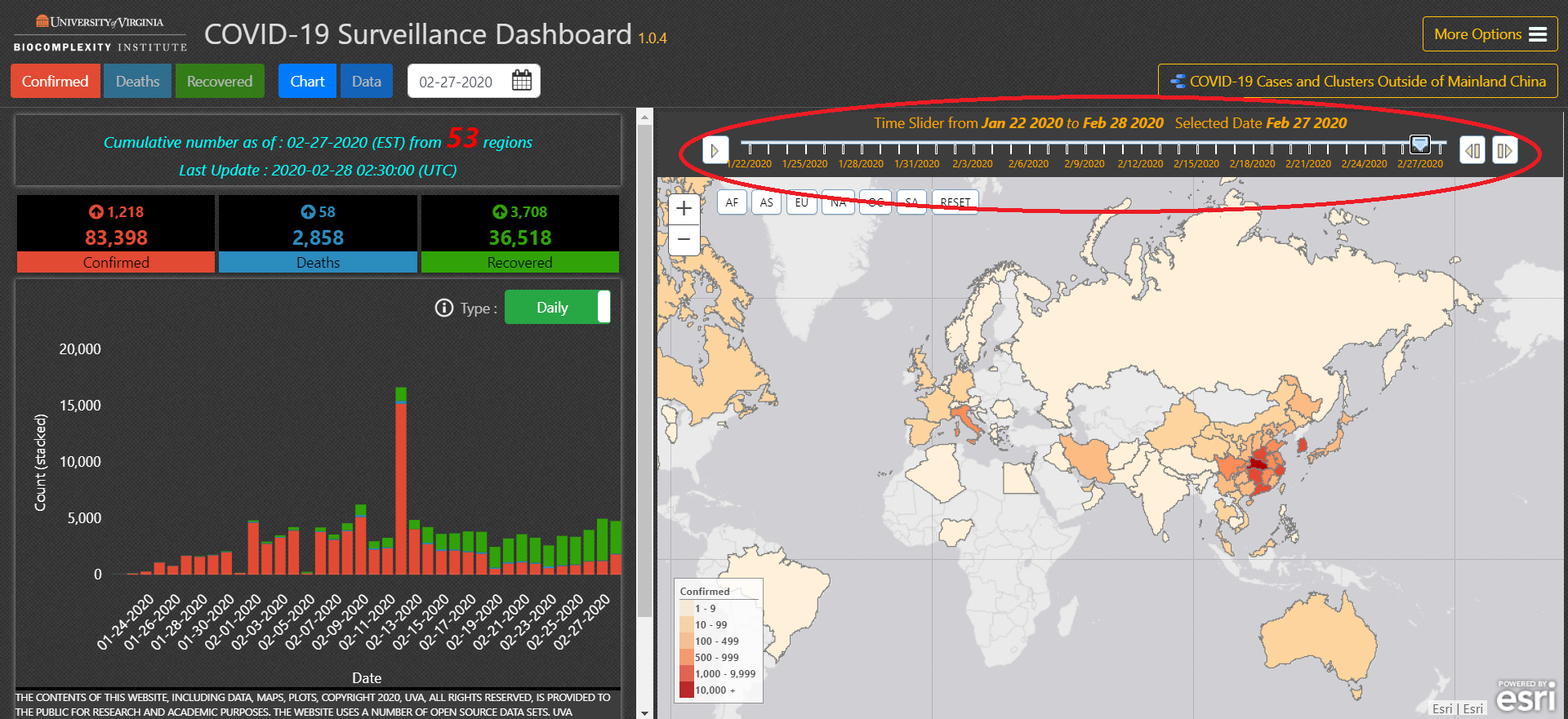
Furthermore, we wanted to draw the attention of our readers to a useful COVID-19 dashboard published by the University of Virginia Biocomplexity Institute at http://ncov.bii.virginia.edu/dashboard/. Note the 'Time Slider' function in that dashboard - cf. https://www.healthmap.org/covid-19/:

University of Virginia Biocomplexity Institute - COVID-19 Surveillance Dashboard 1.0.4

[^Back to top of the page]

On the variations observed between countries

Besides variations in host population make-up (demographics/age structure, ethnicity [US COVID Racial Data Tracker and in the UK: black and South Asian people], disability, existing deprivation and social/health inequalities [also exacerbated by COVID-19], social behaviours [also affecting levels of adherence to lockdown measures], population genetics and blood type distribution [a, b], immunity/vulnerability [including cross-immunity through exposure to other common cold coronaviruses, and even possibly BCG vaccination: a, b, c, d], population prevalence of certain relevant conditions or risk factors, such as obesity [especially in under 60s], diabetes, vitamin D deficiency, etc. [role of smoking is controversial: a, b, c, d, e, f]), country healthcare system characteristics (variations within and between countries), country international travel connections (transport hubs), air pollution (a, b, c, d, e), outbreak timeline in different countries and virus mutations/strains (a, b, c, d, e, f, g) as it spreads, public health interventions (or lack of them) and the timings of their enforcement play a very important role in the differences in disease spread and outcomes we observe between countries.

(As far as climate is concerned, it seems SARS-Cov-2 can survive in hot and humid climates, according to WHO. The virus has spread to countries with both hot and humid climates, as well as cold and dry. MERS, another coronavirus, had no difficulty spreading in Saudi Arabia in August, when it is very hot there. See also: Selection of studies about altitude/humidity and SARS-CoV-2 transmission; Seasonality of SARS-CoV-2: Will COVID-19 go away on its own in warmer weather? The role of population density is a subject of debate: a, b.)

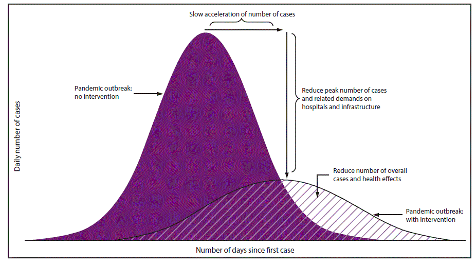
Besides variations in host population make-up (demographics, social behaviours, genetics, immunity/vulnerability, public health interventions (or lack of them) and the timings of their enforcement play a very important role in the variations we observe between countries. Here is a diagram showing mitigated vs. unmitigated responses - "it is not about preventing people from getting infected, but preventing people from getting infected too fast" above a country's healthcare system maximum capacity to cope:
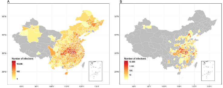
Above figure via WorldPop - Affected areas of COVID-19 in mainland China as of February 29, 2020, under current interventions but with different timings. (A) Affected areas under interventions implemented at actual timing. A total of 308 cities reported cases, based on the data obtained from national and local health authorities, as of February 29, 2020. (B) Affected areas under interventions implemented at two weeks earlier than actual timing, with an estimate of 130 cities affected.

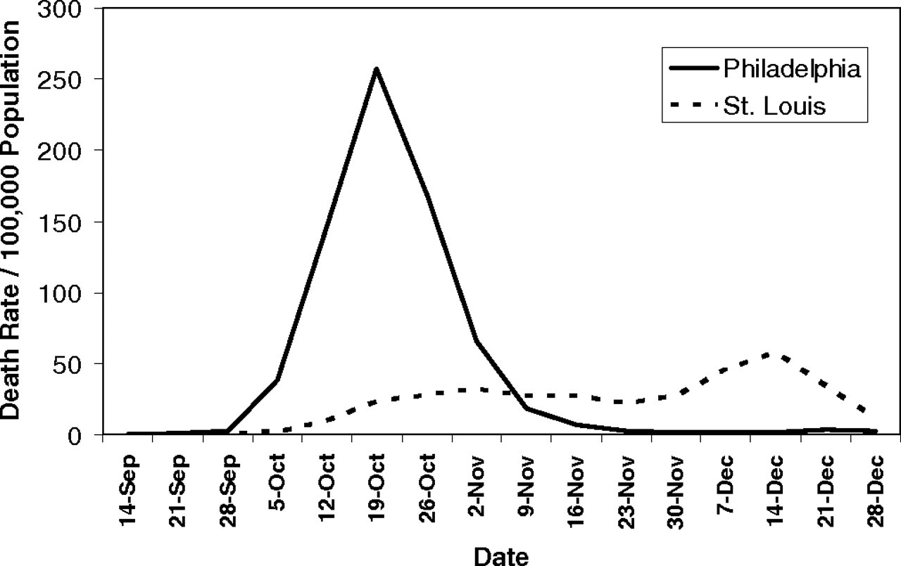
Figure via: Hatchett RJ, Mecher CE, Lipsitch M. Public health interventions and epidemic intensity during the 1918 influenza pandemic. Proc Natl Acad Sci U S A. 2007 May 1;104(18):7582-7. https://www.pnas.org/content/104/18/7582
Above figure via: Hatchett RJ, Mecher CE, Lipsitch M. Public health interventions and epidemic intensity during the 1918 influenza pandemic. Proc Natl Acad Sci U S A. 2007 May 1;104(18):7582-7. "We noted that, in some cases, outcomes appear to have correlated with the quality and timing of the public health response. The contrast of mortality outcomes between Philadelphia and St. Louis is particularly striking. The first cases of disease among civilians in Philadelphia were reported on September 17, 1918, but authorities downplayed their significance and allowed large public gatherings, notably a city-wide parade on September 28, 1918, to continue. School closures, bans on public gatherings, and other social distancing interventions were not implemented until October 3, when disease spread had already begun to overwhelm local medical and public health resources. In contrast, the first cases of disease among civilians in St. Louis were reported on October 5, and authorities moved rapidly to introduce a broad series of measures designed to promote social distancing, implementing these on October 7. The difference in response times between the two cities (≈14 days, when measured from the first reported cases) represents approximately three to five doubling times for an influenza epidemic. The costs of this delay appear to have been significant; by the time Philadelphia responded, it faced an epidemic considerably larger than the epidemic St. Louis faced". Watch the 1918 influenza pandemic documentaryby Lisa laden.

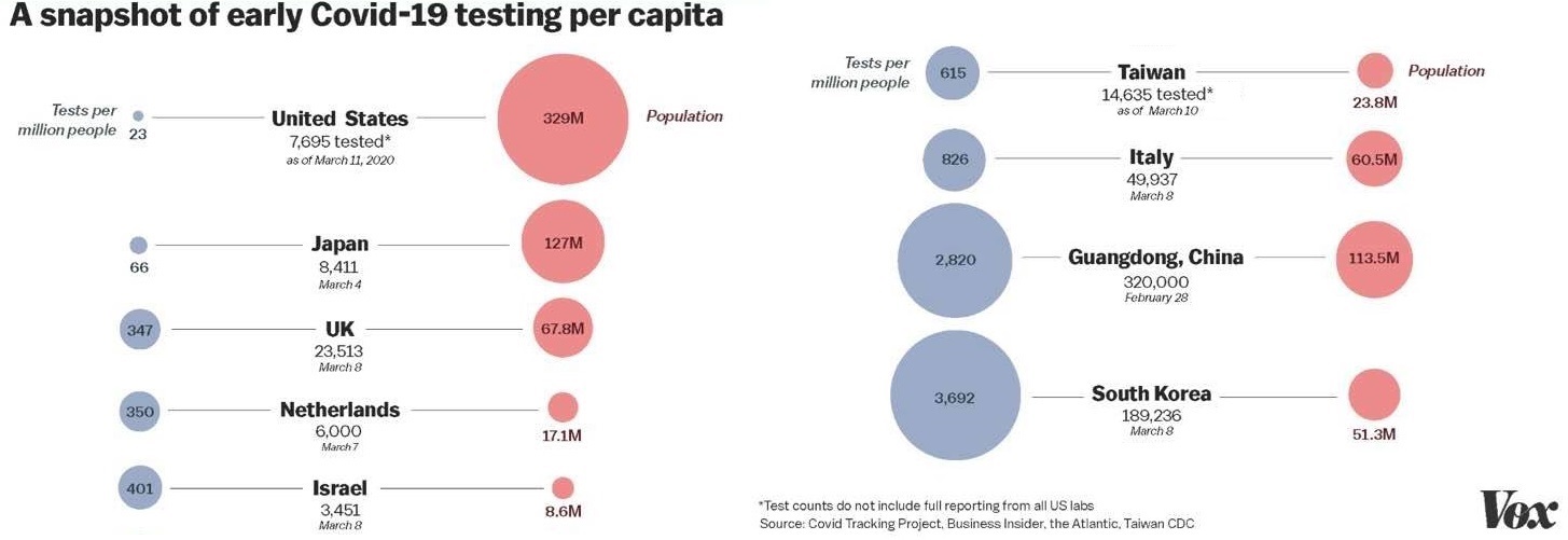
A country's testing capacity to discover/confirm new cases is also very important; underreporting of cases (including milder ones) can artificially inflate or distort mortality and case fatality figures. Furthermore, many COVID-19 deaths go unaccounted for in official statistics (also: a, b, c, d, e, f, g, h; video), and reporting practices and timings vary between countries. See: Average detection rate of SARS-CoV-2 infections is estimated around 6% worldwide in one study. See also https://www.bbc.com/future/article/20200401-coronavirus-why-death-and-mortality-rates-differ - Why are international comparisons difficult? - 'It's tempting to try to construct a league table, but we’ll have to wait months, if not years, for the true picture' and The Covid-19 Riddle: Why Does the Virus Wallop Some Places and Spare Others?

Image source: https://www.vox.com/future-perfect/2020/3/12/21172040/coronavirus-covid-19-virus-charts
Above figure via Vox at https://www.vox.com/future-perfect/2020/3/12/21172040/coronavirus-covid-19-virus-charts. That broad testing in South Korea (>270,000 tests as of mid-March 2020) was launched early along with social distancing, closing of schools and tracing contacts. South Korea figures as of 15 March 2020: total cases: 8162, with 75 deaths (0.9%); curve flattened to lowest number of newly discovered cases in one day (76) since 22 February 2020. (N.B.: The reliability and accuracy of some (rapid) antigen testing kits is questionable (possibility of false negatives). Different centres/countries use different varieties/brands of these kits.)

A few examples of different country and region responses/interventions (from news media articles):

Figure via US CDC - https://www.cdc.gov/mmwr/volumes/66/rr/rr6601a1.htm
Above figure via US CDC at https://www.cdc.gov/mmwr/volumes/66/rr/rr6601a1.htm

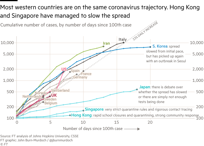
Figure via: Dodd D. Coronavirus business update: all you need to know. The Financial Times, 11 March 2020. https://www.ft.com/content/ff3affea-63c7-11ea-b3f3-fe4680ea68b5

Above figure via: Dodd D. Coronavirus business update: all you need to know. The Financial Times, 11 March 2020. https://www.ft.com/content/ff3affea-63c7-11ea-b3f3-fe4680ea68b5
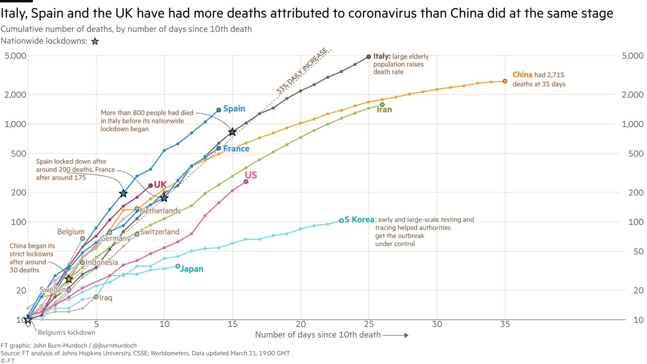
Below: 10 days later as of 21 March 2020 (source: FT). More charts at https://threadreaderapp.com/thread/1244368708249817091.html - Also watch: How coronavirus charts can mislead us

10 days later as of 21 March 2020 (source: FT)

[^Back to top of the page]

Tutorial: a simple geospatial analysis with GIS to understand the spread of coronavirus disease outbreak; data: airport locations and COVID-19 cases

Visit https://www.geo.university/pages/a-simple-geospatial-analysis-with-qgis-and-saga-gis-to-understand-the-spread-of-coronavirus-disease-outbreak

Another tutorial: ArcGIS Solution Coronavirus Case Dashboard Starterkit

A survey of additional COVID-19 public datasets and repositories that can be used for further work to track COVID-19 spread and mitigation strategies is available at https://ieeexplore.ieee.org/document/9184922

[^Back to top of the page]

Genomic epidemiology of SARS-CoV-2 (by country)

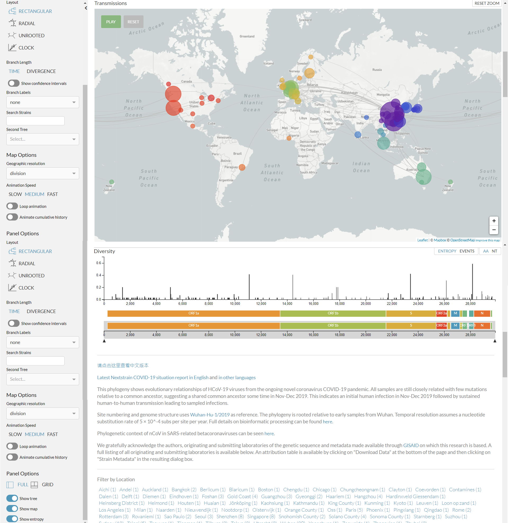
Visit https://nextstrain.org/ncov?c=country

See also:
* Forster P, Forster L, Renfrew C, Forster M. Phylogenetic network analysis of SARS-CoV-2 genomes. Proc Natl Acad Sci U S A. 2020 Apr 8. pii: 202004999.  https://doi.org/10.1073/pnas.2004999117 (news illustrations)
* Kupferschmidt K. Genome analyses help track coronavirus' moves. Science. 2020;367(6483):1176-1177. https://science.sciencemag.org/content/367/6483/1176
* A study combining evolutionary genomics from coronavirus samples with computer-simulated epidemics and detailed travel records to reconstruct the spread of coronavirus across the world in unprecedented detail: https://science.sciencemag.org/lookup/doi/10.1126/science.abc8169

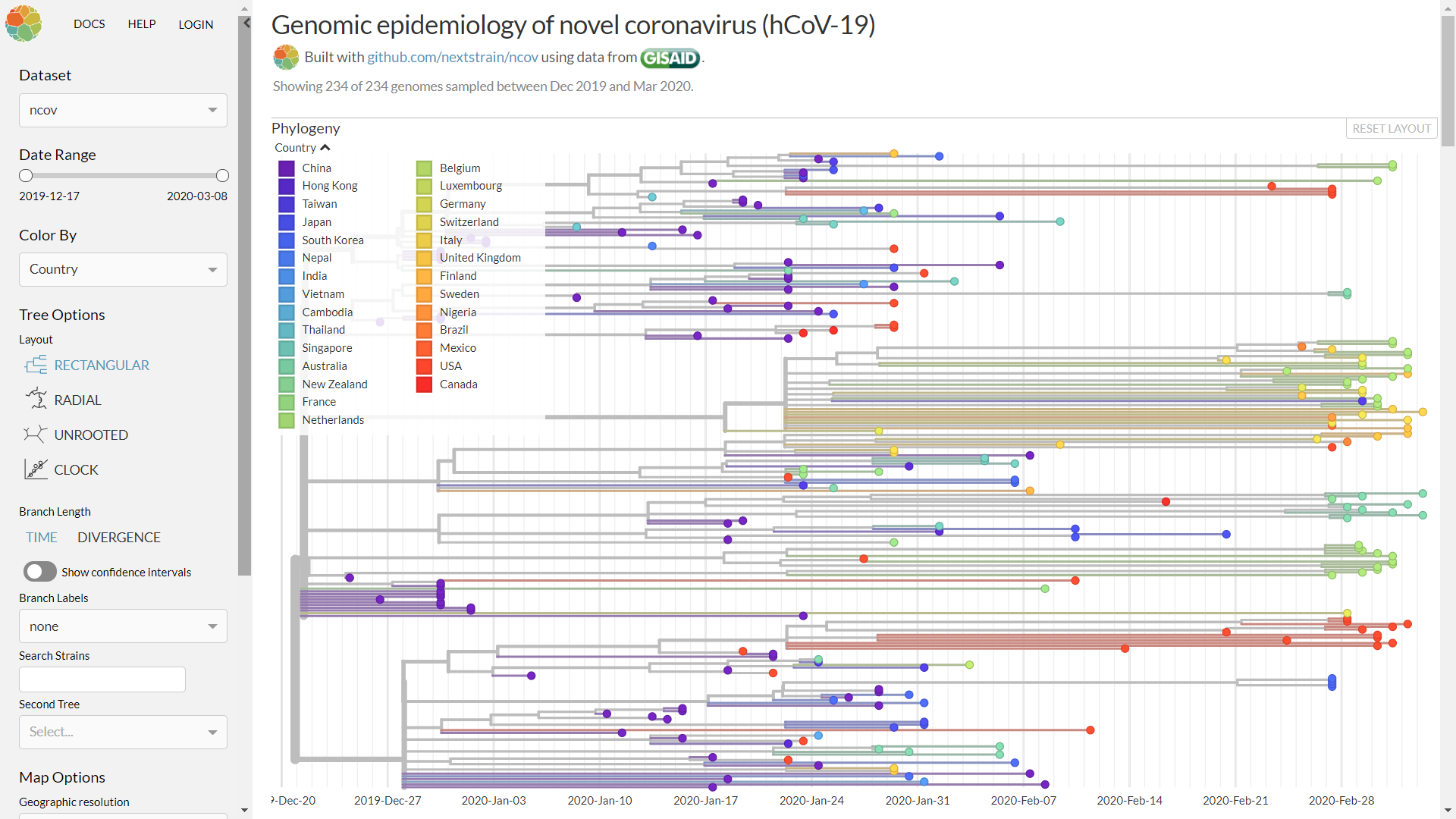
Genomic epidemiology of SARS-CoV-2 (by country) - https://nextstrain.org/ncov?c=country

Genomic epidemiology of SARS-CoV-2 (by country) - https://nextstrain.org/ncov?c=country

[^Back to top of the page]

A live map of crowdsourced COVID-19 outbreak data from around the world, the COVID19 Infodemics Observatory and other online map/dashboard examples

Visit https://www.google.com/maps/d/u/0/viewer?mid=1yCPR-ukAgE55sROnmBUFmtLN6riVLTu3&ll=34.715053812435684%2C0&z=2
Updated every few minutes (as of March 2020). Made by a small team of volunteers from https://www.reddit.com/r/CovidMapping/

Safecast: Documenting Covid-19 testing experiences globally (another crowdsourced map; categories: (i) Refused Testing, Asymptomatic; (ii) Refused Testing, Symptomatic; (iii) Testing Unavailable; (iv) Successfully Tested) (More map examples on Ushahidi)

The COVID19 Infodemics Observatory is available at https://covid19obs.fbk.eu/ (related)

GeoCov19: a dataset of hundreds of millions of multilingual COVID-19 tweets with location information https://ieee-dataport.org/open-access/geocov19-dataset-hundreds-millions-multilingual-covid-19-tweets-location-information (more datasets)

For Bing COVID Tracker, please visit https://www.bing.com/covid

Google COVID-19 data & insights can be accessed at https://www.google.com/covid19/#trends-&-data

IBM and The Weather Channel COVID-19 dashboard

An E-Tracking map of the #CoViD19 in Africa (built using uMap/OpenStreetMap) is available at http://umap.openstreetmap.fr/fr/map/e-tracking-map-of-the-covid19-in-africa_411333#3/10.13/45.34

COVID-19 in Brazil: http://portalcovid19.uefs.br/

During a SARS-Cov-2 epidemic, it is imperative to have detailed data about all ICU facilities and ventilators in the country, government owned or private, and their location, capacity and current levels of occupancy/availability (ideally in real time and in the context of epidemic progression/patient numbers/demand) to inform community response. The Harvard Global Health Institute (HGHI) and the Harvard TH Chan School of Public Health have launched regionalised US capacity estimates under different epidemic loads/scenarios, in collaboration with ProPublica, and in sync with news reports in The New York Times and CBS Morning News at https://globalepidemics.org/2020/03/17/caring-for-covid-19-patients/
See also https://sccm.org/getattachment/Blog/March-2020/United-States-Resource-Availability-for-COVID-19/United-States-Resource-Availability-for-COVID-19.pdf?lang=en-US and https://dash.harvard.edu/handle/1/42599304

A live map of hospital and ICU capacity in Germany https://coronavis.dbvis.de/en/

Medium-Term COVID-19 Forecast by Country (University of Oxford and Australian National University) http://epidemicforecasting.org/

When Will COVID-19 End: Data-Driven Prediction of COVID-19 Pandemic End Dates (in different countries) https://ddi.sutd.edu.sg
(Prediction accuracy will always depend on input data quality and completeness; the latter are known to vary between countries)

Covid-19 Accelerometer: Visualize prevalence, growth rates and acceleration of the pandemic https://theguarani.com.br/

How the virus won (in the US) https://www.nytimes.com/interactive/2020/us/coronavirus-spread.html

Tracking Coronavirus Cases at U.S. Colleges and Universities https://www.nytimes.com/interactive/2020/us/covid-college-cases-tracker.html

LitCovid is a curated literature hub for tracking up-to-date scientific information about the 2019 novel Coronavirus in PubMed; articles are updated daily and are further categorised by different research topics and geographic locations

Satellite images, Internet speed and traffic information tell a whole new story about COVID-19 https://www.wired.co.uk/article/coronavirus-spread-data

In France, people will be able to travel within a 100km radius of their home without an attestation form when deconfinement begins on 11 May 2020 https://100km.space/

Google rolls out new Maps features to protect users from COVID-19

COVID-19 Event Risk Assessment Planning Tool https://covid19risk.biosci.gatech.edu/

Our World in Data: Coronavirus Pandemic (COVID-19) https://ourworldindata.org/coronavirus

COVID-19 Data Index https://www.covid19dataindex.org/

Oxford COVID-19 Government Response Tracker https://covidtracker.bsg.ox.ac.uk/

COVIDPoops19 - Summary of Global SARS-CoV-2 Wastewater Monitoring Efforts by UC Merced Researchers https://www.arcgis.com/apps/dashboards/c778145ea5bb4daeb58d31afee389082

US CDC wastewater surveillance map https://www.healthline.com/health-news/new-cdc-wastewater-map-can-help-you-check-the-covid-transmission-in-your-area

More interactive maps and dashboards: here and at https://atelier8.hypotheses.org/1564

Maps about COVID-19 vaccines: https://covid-nma.com/vaccines/mapping/ and https://vaccinefinder.org/ and https://www.fastcompany.com/90584000/covid-19-vaccine-distribution-5-maps-that-show-how-we-can-get-them-to-everyone

[^Back to top of the page]

Videos showing how 'close contact' and similar apps are being used in China for real-time tracking of nearby COVID-19 cases

Video excerpt from 'Coronavirus in China - A diary from quarantine', a DW (Deutsche Welle) documentary released in March 2020, showing how 'close contact' and similar apps are being used in China for real-time tracking of nearby COVID-19 cases (time position 12:02 to 13:29)

Video of underground COVID-19 tracking and notification service in China (time position 3:55 to 4:23)

China's very effective and sophisticated post-lockdown system: Those who are ill have no chance of avoiding quarantine, and every shop and all public spaces are connected to the system

See also: Taiwan’s app to track local mask supplies amid coronavirus pandemic
(Please note that surgical masks are only to some good extent protective, i.e., not fully protective, but still very useful.)

[^Back to top of the page]

Geotracking and Bluetooth tracking in epidemic response: location privacy vs. public health common good (news links)

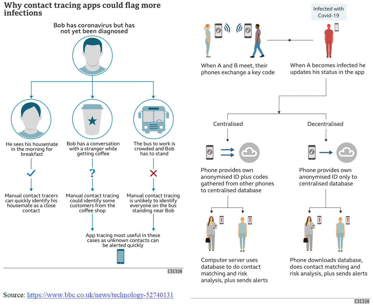
App classes and how they work - by MN Kamel Boulos: A recent study published end of March 2020 concluded that COVID-19 "spread is too fast to be contained by manual contact tracing, but could be controlled if this process was faster, more efficient and happened at scale. A contact-tracing app which builds a memory of proximity contacts and immediately notifies contacts of positive cases can achieve epidemic control if used by enough people".
COVID-19 geotracking apps and platforms use some or all of the following location big data to trace users' movements: smartphone location based on GPS (cannot alone detect vertical separation, such as different floors of same building), WiFi (scanning of nearby WiFi hotspots, plus own IP geolocation) and cellular network data; smartphone bluetooth proximity sensing (distance resolution of a few metres); unique QR codes in meeting venues, train and underground carriages (first pioneered in China's underground, to be scanned by users when they enter venue/board a carriage); and, in some platforms, the location data of users' bank card transactions.
The simplest COVID-19 geotracking apps aim at understanding the spread of the disease, particularly mild cases that are not routinely lab tested, across large geographic regions; for example, the COVID Symptom Tracker app and COVID Near You service. A derivative of this class of COVID-19 geotracking platforms uses anonymised aggregates of location history big data of millions of users (who had chosen to keep their Google Location History turned on) to show how lockdowns are working in different places/countries and measure their success; see Google COVID-19 Community Mobility Reports - cf. Apple COVID-19 Mobility Trends Reports.
More advanced solutions are available for tracking and geofencing those who are under quarantine, either via a dedicated smart wristband and companion smartphone app (as in Hong Kong - though not without its failures) or using the quarantined person's own smartphone, which must be powered on at all times (the user is often sent messages that they must reply to, thus exposing the details of their current location; failure to reply can be an offence).
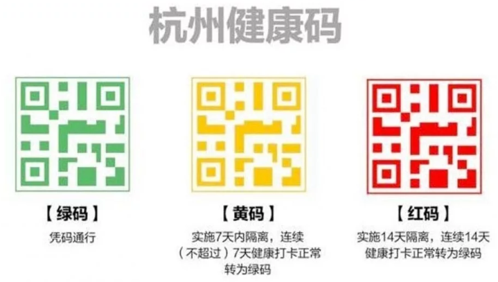
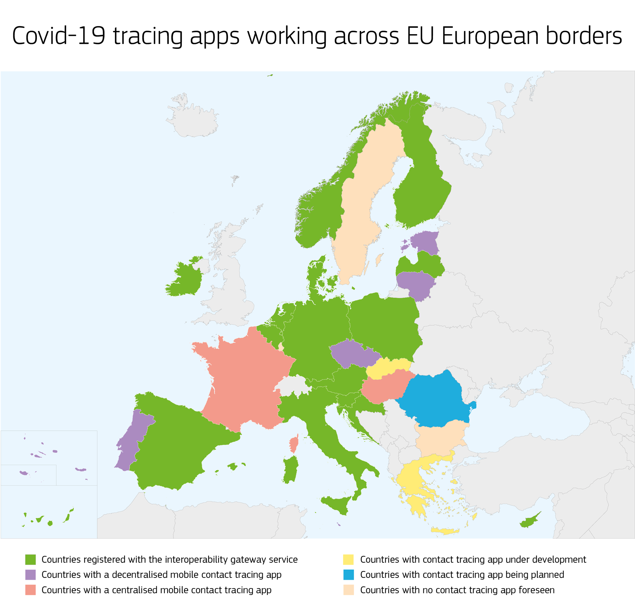
The third major type of COVID-19 proximity (Bluetooth) tracing and/or geotracking apps is meant for healthy people to notify them if they have come across a person who was later diagnosed with COVID-19 so that they can themselves take the necessary precautions, including self-quarantine/self-isolation, and protect their families and neighbours, and to notify authorities to disinfect any train carriages boarded by a person who was later diagnosed with COVID-19. Examples of the latter apps include China's Close Contact Detector app that was launched in February 2020 (see: Kamel Boulos and Geraghty, 2020 - and videos - see also: China's complementary QR health code system), Singapore's TraceTogether app and Israel's HaMagen app, among others. At the time of writing in early April 2020, the UK was planning to launch a similar app. An EU recommendation on apps for COVID-19 contact tracing has also been released, and is expected to guide the design of privacy-preserving contact tracing apps in Europe. Centralised and decentralised approaches exist for contact tracing apps. France, Norway and India have opted for the former approach, which gives public health authorities more control over the contact tracing process, while most EU countries, such as Austria and Germany, as well as Switzerland, have settled on the latter, more privacy-preserving model. All these contact tracing apps, however, are not without their shortcomings, resulting in false positives and false negatives in many scenarios and for a rather wide range of reasons.
Some of the above COVID-19 geotracking apps and platforms use non-anonymised, precise individual location data, and as such raise location privacy and state surveillance concerns, particularly in countries where their use is not optional or voluntary. In fact, the reason some countries are making these apps mandatory is that they do not work well for their intended purposes unless used by enough or all people (one must also consider here smartphone penetration figures in different countries/populations/age groups, e.g., in the UK). Other countries are making these apps voluntary and ask for users' consent to opt-in, and are only using Bluetooth, as a way to mitigate users' privacy concerns. Ideally, users' data should be stored locally on their smartphones and only uploaded to the cloud or kept there when strictly needed to execute the app's functions. During pandemics, public health security and common good clearly outweigh individuals' location privacy concerns. But strict provisions should be in place to ensure all individually-identifiable big data are protected and not use for other purposes after the pandemic is over.
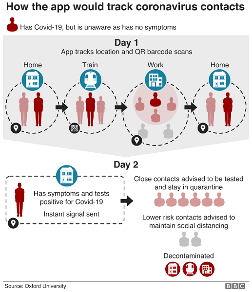
Source: Kelion L. Coronavirus: UK considers virus-tracing app to ease lockdown. BBC News, 31 March 2020. https://www.bbc.co.uk/news/technology-52095331
Above figure via: Kelion L. Coronavirus: UK considers virus-tracing app to ease lockdown. BBC News, 31 March 2020. https://www.bbc.co.uk/news/technology-52095331. Note the use of QR codes for trains and cf. China's approach.
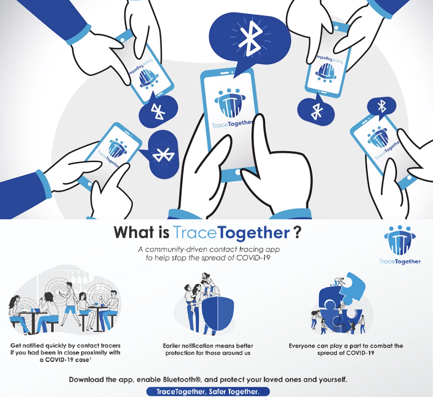
Below: Singapore's TraceTogether COVID-19 app uses Bluetooth signals between phones to detect other participating TraceTogether users (via https://cities-today.com/singapore-launches-app-to-combat-spread-of-covid-19/ and https://www.tracetogether.gov.sg/)

Singapore's TraceTogether COVID-19 app uses Bluetooth signals between phones to detect other participating TraceTogether users - https://cities-today.com/singapore-launches-app-to-combat-spread-of-covid-19/ and https://www.tracetogether.gov.sg/
Source: https://www.bbc.co.uk/news/technology-52263244
Above figure via: Kelion L. Coronavirus: UK confirms plan for its own contact tracing app. BBC News, 12 April 2020. https://www.bbc.co.uk/news/technology-52263244
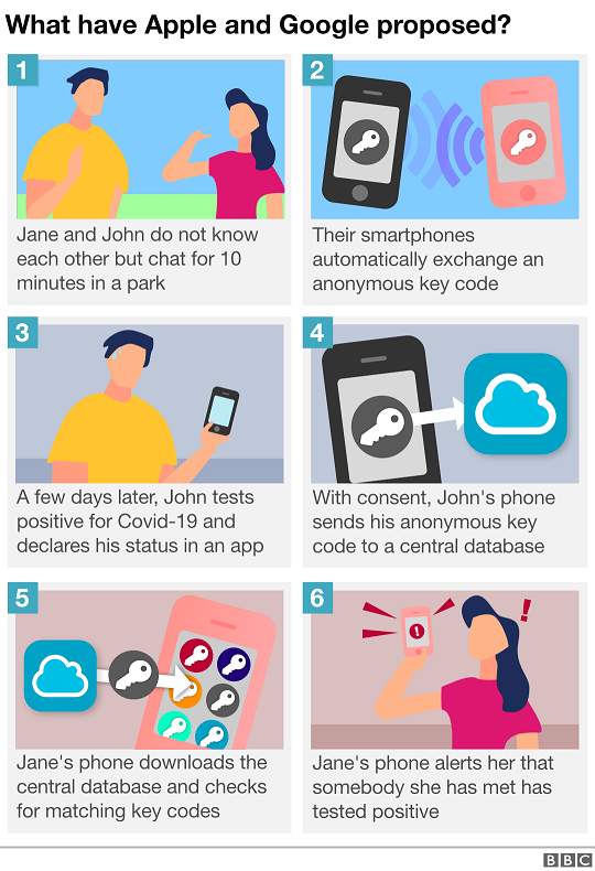
Below: EU privacy-preserving approach using only Bluetooth (users and location are not identified).


Source: Kelion L. Apple and Google release marks 'watershed moment' for contact-tracing apps. BBC News (Technology), 20 May 2020 - https://www.bbc.co.uk/news/technology-52740131
15 countries made their national coronavirus tracing and warning apps work across borders. These apps can now talk to each other and warn users if they were in contact with someone who has indicated that they have tested positive for COVID-19 (16-Mar-2021)
Fifteen EU countries made their national coronavirus tracing and warning apps work across borders. These apps can now talk to each other and warn users if they were in contact with someone who has indicated that they have tested positive for COVID-19 (16-Mar-2021) - via https://www.facebook.com/EuropeanCommission/photos/a.169236379790517/3903326809714770/

[^Back to top of the page]

Satellite images show China and Italy nitrogen dioxide emissions clear amid lockdown

Coronavirus: nitrogen dioxide emissions drop over Italy http://www.esa.int/ESA_Multimedia/Videos/2020/03/Coronavirus_nitrogen_dioxide_emissions_drop_over_Italy (Europe)

Coronavirus: Nasa images show China pollution clear amid slowdown https://www.bbc.co.uk/news/world-asia-51691967

UK: https://www.bbc.co.uk/news/uk-england-52202974

Coronavirus Has Slashed Global Air Pollution. This Interactive Map Shows How: https://dhruvmehrotra3.users.earthengine.app/view/earther-time-series

See also: https://www.nasa.gov/feature/goddard/2020/nasa-funds-four-research-projects-on-covid-19-impacts

[^Back to top of the page]

On pandemic preparedness, early warning and response: TED talks by Larry Brilliant (2006) and Bill Gates (2015)

Larry Brilliant, the epidemiologist who helped eradicate smallpox https://www.ted.com/talks/larry_brilliant_my_wish_help_me_stop_pandemics/transcript?language=en

Bill Gates https://www.ted.com/talks/bill_gates_the_next_outbreak_we_re_not_ready/transcript

[^Back to top of the page]

"Updating your models and predictions in light of new evidence and new inferential methods and insightful counterpoints from colleagues isn't a sign of weakness, it's *doing science*. We don't stake out positions on day 1 and then defend them as if our reputation depends on it. Rather, reputations depend on being flexible in light of new findings. You don't drop an idea just because it is criticised; you fight for it. But you also walk away when it's time."
--Carl T Bergstrom

"This virus does have the ability to transmit far easier than flu. It's probably now about three times as infectious as flu. One of the [pieces of] information that we have pretty much confirmed now is that a significant number of individuals that are infected actually remain asymptomatic. That may be as many as 25%. That's important, because now you have individuals that may not have any symptoms that can contribute to transmission, and we have learned that in fact they do contribute to transmission. And finally, of those of us that get symptomatic, it appears that we're shedding significant virus in our oropharyngeal compartment, probably up to 48 hours before we show symptoms. This helps explain how rapidly this virus continues to spread across the country, because we have asymptomatic transmitters and we have individuals who are transmitting 48 hours before they become symptomatic."
--Robert Redfield, US CDC Director (see also: aerosol transmission of SARS-CoV-2)

This is not like seasonal flu: Significant numbers of young people, but also some teenagers (12-19), can and do become critically unwell and die from COVID-19. A review of more than 4,000 US patients who were diagnosed with COVID-19 shows that an unexpected 20% of deaths occurred among adults aged 20-64 years, and 20% of those hospitalised were aged 20-44 years, increasing to 40% when age range is extended to 54 (20-54 years) (Source: Severe Outcomes Among Patients with Coronavirus Disease 2019 (COVID-19) — United States, February 12–March 16, 2020. MMWR Morb Mortal Wkly Rep 2020;69:343-346. DOI: http://dx.doi.org/10.15585/mmwr.mm6912e2). The US CDC also researched 49,000 coronvavirus cases between February 12 and April 9, 2020,  and found that 9,300 of them, 19%, involved healthcare workers. SARS-CoV-2 is unusual in that it manages to block the interfeon-I and III response quite thoroughly, while setting off a larger-than-normal cytokine secretion response. (If you add IFN-I back to the infected cells in culture, they clear the virus very strongly – the machinery is working, but it is just not being engaged.) COVID-19 mortality might be due to virus-activated 'cytokine storm syndrome' (but see here) or fulminant myocarditis (cardiac injury) or abnormal clotting (hypercoagulation) and endotheliitis across different organs. Silent hypoxia might be a reason why so many early cases are missed until they become severely complicated or fatal. In infants and children: PIMS-TS. Transplacental transmission of SARS-CoV-2 infection has been documented. There is also evidence of persistent symptoms in many patients after acute COVID-19. In July 2020, UK neurologists published details of mildly affected or recovering Covid-19 patients with serious or potentially fatal brain conditions. There is also mounting evidence that herd immunity to Covid-19 is 'unachievable': a, b. "Immunity can be incomplete, it can be transitory, it can last for just a short time and then disappear," Raquel Yotti, the director of Spain's Carlos III Health Institute, said. Related: T-cell immunity with SARS-CoV-2 and the Nsp1 protein of SARS-CoV-2.
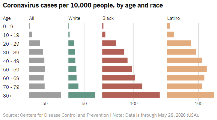
Coronavirus cases per 10,000 people, by age and race. Note: Data are through May 28, 2020 (USA)
See also: Complications from COVID-19 may depend on von Willebrand factor in the blood and other genetic factors that may influence COVID-19 susceptibility.
[^Back to top of the page]


Page compiled and written by Maged N Kamel Boulos, February 2020-February 2022